 Hotel Booking, Tour and Travel Planning, Online Tickets Tour Planning, Designing Packages, Hotel Booking
Pin Bhaba Pass Trek Date, Timings, Charges, Booking\
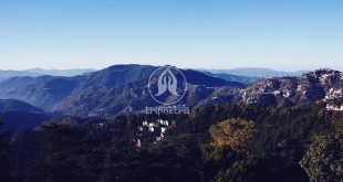
Pin Bhaba Pass Trek of the Himachal region is one of the best things to do especially in monsoons. The trek is more dramatic changing the scenery daily. The Mulling dark forest, the tall coniferous trees, pine trees leave you speechless with its exotic beauty. The trek is more unique as it offers you the look of Kashmir at the Karah. Every step you head to trek the pass is unique and beautiful, the Phutsirang, the subterranean river, the fresh breeze, the flower beds everything on the route is special and filled with beauty.
Trekking Price:
Rs 14,500/- per head (Approx.)
Itinerary for Pin Bhaba Pass Trek
Day 1:
- Start (Drive) from Shimla to Kafnu
- The altitude ranges from 7,465 ft to 7,878 ft.
- Distance is about 205 km
- Duration of 6 to 7 hours’ drive.
- Base Camp at Kafnu.
- Trek will start in the next day morning from Kafnu to Mulling.
Day 2:
- The altitude ranges from 7,878 ft to 10,637 ft.
- Distance is about 11.3 km
- Duration is 8 to 9 hours
- On this trek one can spot Bhaba Hydro Project, Crossing Bridge, Bhaba River, beautiful forest, Jhandi Top (10,640 ft). etc.
Day 3:
- Trek from Mulling to Karah
- The altitude ranges from 10,637 ft to 11,653 ft.
- Duration is about 5 hours of trekking
- Distance is about 6 km
- On this trek one can spot, flower beds, waterfall, subterranean river.
Day 4:
- Trek from Karah to Phutsirang
- The altitude ranges from 11,653 ft to 13,474 ft
- Duration is about 4 to 5 hours
- Distance is about 5 km
- This zone shows you the combination of stone and loose mud.
- This is the smallest trek of the whole
- After trekking 700 meters one can reach Phutsirang.
- Phutsirang gives a beautiful view of Nimish Khango (16,185 feet),
- Tari Khango (17,318 feet) and Pin Bhaba Pass, Wang Khango (16,105 feet) mountain passes.
Day 5:
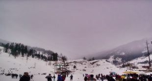
- Rest at Phutsirang Campsite and enjoy at the grand vintage point.
Day 6:
- Trek back from Phutsirang to Mangrungse via Pin Bhaba Pass
- Altitude is about 13,474 ft to 16,105 ft to 13,674 ft.
- Duration of 9 to 10 hours
- Distance 11 km
- On the trail one can spot the Pin Valleys, saddle point of the pass, combination of moraine, glacier and scree, Pin river.etc.
Day 7:
- Trek from Mangrungse to Mudh
- The altitude is about 13,674 ft to 12,283 ft.
- Duration of 7 to 8 hours
- Distance is about 16.30 km
- Trek from Mangrungse to Bara Boulder Campsite from there head to the village.
Day 8:
- Drive from Mudh to Manali
- Distance is about 201 km between Mudh and Manali. From Manali one can head back through their respective means of transportations (By Air, By Rail or By Road ways).
Trek Distance:
49 to 50 km Trek
Time Taken to Trek:
8 Dyas Trek Duration
Note: If the weather is bad one has to go through the Buffer Day (Also the respective tariff to be paid if not your amount will be refund back from the trek leader)
Note: Carry Food & Snacks to avoid hunger as limited stalls are available in the area.
Best Time to Visit:
July to August
How to Reach this place?
By Air:
Jubbarhatti Airport is the nearest Airport which is 25 km away.
By Railway Station:
Kalka Railway Station is the nearest Railway Station which is 38 km away.
By Road:
Shimla is well connected with other major cities; also many private vehicles ply directly to Shimla.
Reference Link: details