 Hotel Booking, Tour and Travel Planning, Online Tickets Tour Planning, Designing Packages, Hotel Booking
Rupin Pass Trek Charges, Package, Online Booking, Route info.
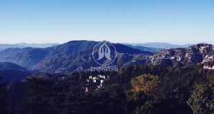
Rupin Pass Trek is one of the best trekking destinations of Himachal Pradesh. The trekking is a moderately difficult trek. One has to drive from Dehradun to Dhaula a small hamlet. As the base camp is arranged at Dhaula one has to gather and get acclimatize to trek. On this trek one can explore the beauty of snow caped mountain ranges, colourful flowers covering the paths and the fresh water flowing through the Rupin river is spectacular to watch. The trek has some interesting points like the ancient temple, the bridge, the river and the small Himachali homes and much more to explore at the Rupin Pass.
Trek Price:
Rs 14,500/- per head (Approx.)
Itinerary for Rupin Pass Trek
Day 1:
- Drive to Dhaula
- Dhaula (hamlet) is the base camp
- The altitude ranges at5,100 ft
- Distance is about 10 to 11 km from Dehradun to Dhaula
- Duration of 5 hours’ drive from Dehradun
- Trek at Dhaula covers the beautiful mountain roads, deep valleys, thick forests’.
Day 2:
- Reach Dhaula to Sewa
- The altitude ranges from 5,100 ft (1,554 m) to 6,300 ft
- Duration is 5 to 6 hours.
- Trekking Distance is about 11 km
- Water can be filled from the Rupin River.
- At Sewa one can spot the 2-story temple.
Day 3:
- Trek from Sewa to Jiskun
- The altitude ranges from 6,300 ft to 7,700 ft.
- Duration is about 5 to 6 hours for trekking
- Distance is about 8 km
- On this trek one can spot river bank, Haldi Khad (Campsite), Gosangu.
- Note: Carry Food & Water as no such sources are available at this zone.
Day 4:
- Trek from Jiskun to Udaknal
- The altitude ranges from 7,700 ft to 10,100 ft
- Duration is about 5 to 6 hours
- Distance is about 8 km
- One has to trek to 3.5 km to Jakha which is the highest and last village of the Rupin Pass trek.
- Thre trail will later descends to deodars forests, wooden bridge from there head to Jakha.
Attractions:
- Zig-Zag trails
- Mixed Forests
- Whistling Birds
- Blue Pines
- V-Shaped Valley
- Snow bridge
- Pleasant Sceneries.
Day 5:
- Trek from Udaknal to Dhanderas thatch which is the lower water fall camp
- Altitude is about 10,100 ft to 11,700 ft
- Duration of 5 to 6 hours
- Distance 6 km
- Note: Carry Water and some Snacks also one can refill the bottles from the river
- The trek gives a glimpse of beautiful Rhododendrons flowers in various colours purple, pink and white.
Day 6:
- Head to Dhanderas Thatch and get acclimatize and get ready to trek.
Day 7:
- Trek from Dhanderas thatch to the Upper Waterfall camp
- Altitude is about 11,700 ft to 13,100 ft
- Duration of 3 hours
Day 8:
Trek from Dhanderas thatch to the Upper Waterfall camp
Altitude is about 11,700 ft to 13,100 ft
Duration of 3 hours
Day 9:
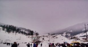
- Trek to Upper Waterfall camp to Rupin Pass via Rati Pheri, further on to Ronti Gad
- Altitude is about 13,100 ft to 15,380 ft to 13,100 ft
- Duration of 10-12 hours
- Trek through the valley of snow-covered paths, Sangla side of the mountain, Dhauladar range.
- Rest at the Campsite.
Day 10:
- Trek from Ronti Gad to Sangla Via Sangla Kanda
- Altitude is about 13,100 ft to 8,600 ft via 11,427 ft
- Duration of 6 hours
- One can spot Kinner Kailash range and the blue pines of the Baspa valley.
- From there one can head back to the Dhaula and from there to Dehradun
Trek Distance:
25 to 35 km Trek
Time Taken to Trek:
9 Dyas Trek Duration
Note: If the weather is bad one has to go through the Buffer Day (Also the respective tariff to be paid if not your amount will be refund back from the trek leader)
Note: Carry Food & Snacks to avoid hunger as limited stalls are available in the area.
Best Time to Visit:
July to August
How to Reach Kedartal Trek Himachal?
By Air:
Jolly Grant Airport is the nearest Airport which is 225 km away.
By Railway Station:
The Nearest Railway Station is at Rishikesh which is 280 km away.
By Road:
Regular Buses ply from Dehradun to Gangotri.
Reference Link: details